


Search
Marine Protected Area of Torre Guaceto
 |
||
| Legal statut : | Marine Protected Area and Natural reserve |
|
| Foundation year : | 1991 | |
| Foundation text : | Ministerial Decree | |
| Management body : | Consortium between the municipalities of Brindisi and Varovingno and W.W.F |
|
| Surface : | 2 227 ha | |
| Inclusion in the SPAMI List: |
2007 |
Territory
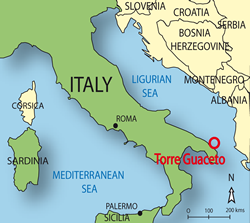
The Marine Protected Area, falling within the municipalities of Brindisi and Carovigno, is about 8 km long from the zone of Apani till the littoral of Punta Penna Grossa.
Physical features
The coastline is characterized, along the western sector, by a series of small subrectangular coves with pocket beaches. At East, the coast is mainly sandy, with reduced rocky formations and low rocks emerging right, characterized by a regular, sinuous coastline. The eastern coastal sector is incised by ten little valleys, some continuing underwater.
The emerged coast is characterized by two primary grooves that generate two coastal coves. Numerous secondary grooves can be detected in the whole submarine area, forming a late-pleistocenic hydrographic reticulum with parallel pattern. The marine bottoms are always characterized by the presence of two submarine cliffs, running parallel to the coast line, with a medium slope, whose physiognomy is articulated and presents a convexity.
Specificities and importance
The euryhaline, eurythermic, brackish water community is characterized by the presence of the marine phanerogam Zostera noltii.
The rocky midlittoral is characterized by the presence of red algae as Laurencia sp, and Corallina elongata and by a Cystoserietum that forms belts along the rocky littoral.
The rocky infralittoral is characterized by photophylous algae and by sea urchin barrens and encrusting algae accompanied by the few animal species that resist the grazing activity of sea urchins. Posidonia oceanica meadows are one of the most characteristic habitats of the sandy infralittoral. The intricate morphology of the meadows forms a series of microhabitats that provide both food and shelter to numerous organisms, from fish and crustaceans to sponges, bryozoans, hydroids, anthozoans and bivalve mollusks.
Some of the precoralligenous formations, mostly localized in front of the Tower of Guaceto, at 15-17 meter depth, are characterized by patches of high density of gorgonians of the species Eunicella cavolinii, E. singularis and E. seeranova.
Threats and pressures
The use of maritime national properties and adjacent areas present may impact on natural resources such as: impact on aquatic populations deriving from the collection of coastal benthic organisms by visitors of the Reserve; impact on the abiotic compartment of the aquatic environment, etc.
Non controlled discharges of undetermined organic and inorganic pollutants have impact on the soil compartment of the coastal zone. Marine pollution due to the stranding of solid inorganic reject and to the organic charge that is transported along the littoral from the Northern Adriatic and from Albania due to winds and currents, cause their accumulation near the Promontory in the no-take zone.
The invasive species Caulerpa racemosa is also very common.
Management
A management plan has been formulated by an expert team with the participation of institutions and stakeholders and was approved in 2002.
A zoning shares the MPA in 3 zones:
- Zone A: No take zone
- Zone B: general Reserve, where fishing, harvesting; entry, sailing and approaching of all kinds of craft are forbidden
- Zone C: partial Reserve where fishing is allowed.
11 members are involved in the MPA. The funding for the basic staff, protection and information measures are provided by the Environmental Ministry.
The management body of Torre Guaceto integrates the activity of surveillance of the national and local institutions with its own personnel (five units). The adequacy of the surveillance and protection is very high; this is demonstrated by international scientific publications.
The knowledge of the MPA is high, considering the main ecological processes, habitat distribution, inventories of species and socio-economic factors. This is due to the numerous research programmes that have been carried out, with the production of the biocenotic map.
The programmes of environmental education envisage a fundamental relationship with the school system and the Reserve of Torre Guaceto. After years of continuous activity, this is now an important benchmark for environmental education in the whole Apulia Region, being visited thousands of students every year.
Activities of environmental information, formation and education are parts of a wider regional strategy, since the Experience Centre of Torre Guaceto is located in the Visitors Centre at Serranova.
Find Us On...