


Search
12/20: Virtual school of oceanography from space – summary of the event

The Virtual School on oceanography from space, organized by UNEP/MAP-SPA/RAC, was carried out successfully from 23 to 27 November, with a sustained attendance of over 80 participants.
In the framework of the European Union funded project ODYSSEA, UNEP/MAP-SPA/RAC organized the 3rd ODYSSEA School, from 23 to 27 November, with the support of the project partners and the collaboration of specialists from renowned organizations in the field of satellite data processing, such as EUMETSAT, LEGOS and ORBITAL-EOS.
The main goal of the ODYSSEA School is to give technical skills to the participants in handling satellite and in-situ data in synergy, and to develop marine research approach based on multi-sources information, allowing them to become ready to face the challenges of the next decade 2021-2030, which has been declared by UN as the decade of Oceans.
The Virtual School was attended by over 80 participants from 26 countries of five continents, working on the field of physical oceanography or marine environmental sciences.
Opening the first session, Mr Khalil ATTIA, SPA/RAC Director, underlined that the main goal of the ODYSSEA School is to give technical skills to the participants in handling satellite and in-situ data in synergy, and to develop marine research approach based on multi-sources information, allowing them to become ready to face the challenges of the next decade 2021-2030, being declared by UN as the decade of Oceans.
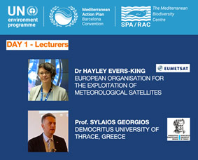
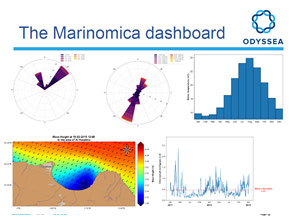
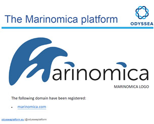
Professor Georgios SYLAIOS, from the Democritus University of Thrace (Greece), and coordinator of the ODYSSEA project, pursued with the first training session to introduce the webinar. He stressed the importance of satellite data and the Copernicus program for the ODYSSEA project. He explained how the ODYSSEA platform (marinomica.com) is designed to facilitate the access and processing of oceanographic data to a large public and end-users, who need to explore such data for their daily activities.
The second lecturer, Dr Hayley Evers-King, marine specialist at the European Organization for the Exploitation of Meteorological Satellites (EUMETSAT), gave an overview on the satellite functionalities for Ocean monitoring at different spatial and temporal scales.
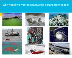
Dr Evers-King presented the panoply of Earth Observing Satellite of the European Spatial Agency currently in orbit (SENTINEL), how to access to the data through different platform and why we would want to observe the oceans from space in different domains. During the course, Dr Hayley Evers-King focused especially on measuring sea surface temperature and ocean colour from space, using respectively Thermal Infrared Radiometer and Visible imaging multi-spectral radiometers.
Other types of sensors are also available to investigate other physical parameters characterizing the ocean. For instance, Dr Florence Birol (French Laboratory of Geophysical Studies and Spatial Oceanography, LEGOS) explained extensively the use of Radar Altimeter data to track the variability of Sea Surface Height (SSH), both in the open ocean and in the nearshore area. A special focus was given to the new developments in the use of altimetric data in the coastal zone and dedicated tools for processing and analysis (X-track). LEGOS team (Florence, Fernando Niño and Fabien Leger) provided tutorial material for the webinar attendees and a session was dedicated to the processing of altimetric data using python scripts.
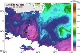
Based on altimetric data processing, as well, Dr Cori PEGLIASCO, from CLS (Collecte Localisation Satellite, France) showed how Meso-scale eddies dynamics are detected and tracked and explained the correlation between Sea Level, Temperature and chlorophyll concentration within eddies, and their importance in sea water mixing and enrichment by nutriments in different key-zone of the Mediterranean.
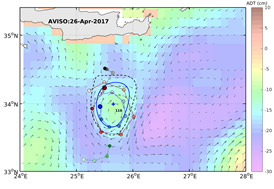
As they play a dominant role in heat and energy transport, eddies must be accurately addressed by earth observing systems, as pointed by Dr Katerina SPANOUDAKI during her lecture on hydrodynamic models validation using satellite data assimilation.
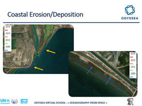
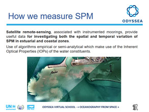
Two other applications on the use of satellite data to monitoring the coastal environment, were presented by Konstantinos ZACHOPOULOS and Dr Nikolas KOKKOS (Democritus University of Thrace, Greece), respectively, on coastal erosion patterns and Suspended Particulate Matter in coastal water.
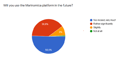
Finally, a very important outcome of the ODYSSEA project, which is the Marinomica platform, was presented during the training webinar by Simon Keeble, manager of the Blue lobster Inc.
Marinomica is a word built from Marine and Economic, with reference to the Blue Economy and Blue Growth concept.
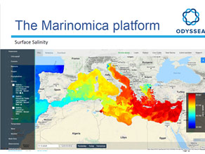
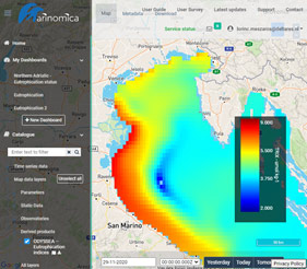
Dr LÖRINC MÉSZÁROS, Specialized in Hydro-informatic at DELTARES, presented an innovative application implemented on Marinomica, which allows the calculation of Eutrophication indices, a fundamental parameter for the assessment and monitoring of the Good Environmental Status of the Mediterranean Sea.
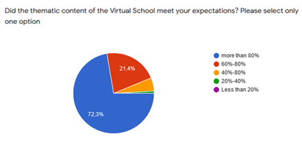
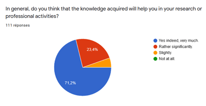
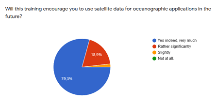
Following the training webinar, an evaluation was performed through a survey among the participants. The answers received showed an excellent appreciation of the training and a relevance of the chosen themes with regards to their expectations.
ODYSSEA is an EU-funded Research and Innovation project – Grant agreement No 727277
Find Us On...